Free counters!

Scenic

Nature is painting for us the Pictures of infinite beauty.

Untarnished

Yeah, it's a little more than what I call amazing ..

Heritage

World Class, Man-made wonders.

Essence

Home away from home!

Holy

Peace comes from within. Do not seek it without.

Sunday, June 17, 2012

Horton Plains


One amazing place, most probably the coldest and windiest place in Sri Lanka!
Rich in flora and fauna. Located in the central highlands. About 30 km from Nuwara Eliya, 40kms from Haputale. Ones who come from Nuwara Eliya can reach to the entrance poin in Pattipola, while the ones from Haputale reaches the entrance point in Ohiya.

Herds, deers are very regular sights in Horton Plains.

There is a one special place called 'World's End' in here. As the name sounds, there is a sudden end of the path in that so called place! From there you can see a huge fall, and the sight runs to 10km ...

Due to the high variety of nature, Horton Plains was declared a UNESO World Heritage Site in 2010.


If you planing to visit Nuwara Eliya, this is the 1st place that you should add to your list :)
Even we Sri Lankans rarely misse this place when we are going trips to Nuwara Eliya!


Photo Gallery


Sunday, November 13, 2011

Sigiriya Rock Fortress

Another famous tourist destination. The best place to ensure the rich culture of Sri Lanka.

Little bit from the History (just leave this para, if you feel shiftless...)
This was built by King “Kashyapa”. He killed his father to get the kingship early. Kashyapa had a brother called “Mugalan” and he was very angry about this. He went away from the palace with challenging Kashyapa that one day he would come back with an army. Kashyapa knew that his brother had a great military knowledge and therefore he wanted to ensure his security. Then he built this fortress. (However it is said that his brother gained the victory later)

Sigiriya is situated in Mathale District, about 40 miles away from Anuradhapura. From far away, the rock seems like a lion standing in a jungle. One important thing about this place is that there are no more rocks near by. It brings more safety to the fortress; otherwise the enemy can easily attack with the help of another rock.
Sigiriya rock has a unique shape: the ones who know it well can easily recognize it from far away, even from the central province. (When you are climbing the Hill country, you will pass “Kadugannawa” and there is a ‘site watching place’ near Kadugannawa. You can recognize this rock even from there)

When you enter to the garden, don’t rush to climb! There are many things to watch first. Just take a 360’ turn! You can understand how biggy the garden is! Yeah, probably I could say a Garden Complex :). It is true if I say, this is one of the oldest landscaped gardens in the world.
As this is a fortress, the garden is not only for beauty! The garden can be divided to 3 sections and each of them is surrounded by drains. First section is just the beauty. Second one has few security features and the last section is totally a mess of Security! There were even some Crocodiles in the drains of the last section of the garden (Don’t worry, see I just used “were” :P )

When you are climbing, there are some places that you should wait and enjoy. Sigiriya Frescoes and The mirror wall are few of them.


 <Frescoes>

King Kashyapa was a fine artist. Sigiriya frescoes prove that.  These frescoes were drawn on the whole face of the hill. According to researches, these are painted in 8th century and still in good form (even with colors). Researchers also said that there are many similarities between these and “Ajantha” Paintings in India. However the females depicted there are extremely beautiful. They are known as the daughters of King Kashayapa. (Some people say they are the wives of him).


One the way to top, there is a wall called mirror wall, a wall made with polished stones. Some say this was to cheat the invading armies. However the graffiti written on the mirror wall by visitors later are wonderfully composed and it seems like most of them had composed poems with the impression of Frescoes.

Before entering to the peak, you will come to some sort of floor. There you can see the paws of a huge Lion. You won’t see the head of the lion, because it was missing since a long time ago :(  .  Creep through those paws to climb up.

At the top of the rock you can see the ruins of a palace. Can you believe; how the building materials were taken to the top of the rock is still unknown, because even with the modern machinery it is difficult to reach such a rocky height :). That is the main reason to consider this as the 8th wonder of the world.
Well, I think this place is really suitable for taking Panorama shots.. so try that too..


Location                         :  Central Province

Known for                      : Rock fortress, Frescoes, Graffiti,  

Geographical coordinates: 7° 57' 0" North, 80° 45' 0" East

Climate                           :  Sunny (usually)

Challenge from me          : I just mentioned above a spot in Kadugannawa where you can watch this rock clearly. When your car stops at that place… try to recognize it yourself :D


CAUTION: There are some hives of honey bees in few places in the rock. DON’T DO ANYTHING THAT CAN PROVOKE THEM. (even your drastic perfume or  a cigarette could stir up them)


Gallery

The rock from far away


Little bit closer..


The Garden Complex


A Section in the Garden


Paws of the Lion

  
Climbing up!


Peak


Tuesday, November 8, 2011

Sri Pada (Adam's Peak)


This is the only mountain in the world that four religions worship. This is a holy place for Buddhists, Christians, Hindus and Muslims. In each of those religions, this mountain is interpreted in their own ways.
According to the Buddhism, Sri Pada was once visited by the Lord Buddha. There is a sacred footprint in the top of the mountain and Buddhists consider it as the footprint of Lord Buddha.
In the same manner, Christians believe Adam had visited here and kept his footprint as a signature, while Hindus consider it is the footprint of Lord Shiva.
Never mind the proprietor of it, this place has become a symbol of Peace and Harmony.


There is a certain period for climb this. Usually the term is from December to May (Full moon day of Dec. to the same day in May). 
Most of the people, start climbing at the evening to miss the effects of sun rays and at the dawn of the next day they could easily finish climbing. (The mountain is not that much high to climb around 10 hours, but with watching the beauty and having some rests while going may take more time) 
If you visit there, you may understand there is a culture of climbing it! (Yeah! I could say ‘a culture’). The climbers address the ones who are coming down in the same path with sweet poems. Then they also reply with a poem in return. There are some well known poems, but what is mostly done is making poems in real-time! The other teams that climb around you will exchange sweetmeats with you (well don’t worry if you have no sweetmeats, just give them some Chocolate bars or slices of Cheese and other ‘your country made’ food :P )


There are few paths to climb it. I’m sure that your guide knows all of those (it is such famous) and therefore you should tell him your desires: if you need to enjoy the flora and fauna while climbing or if you need to rush to the top as quick as possible or if you need the safest path, like wise.

If you are lucky enough, you will be able to see the colorful view of Sun rising. The Sun is just peeping from the ocean and lil by lil going upwards feeling quite shy! I’m sure this would be a busy time for your cameras :D


From May to December, the climate there is getting bad with rain, extreme wind and the thick mist.
But one of my uncles once visited there in August with a group of tourists, and he said although it was a risky task, that satisfaction you gain after climbing to the top is commendable! Therefore, if you are expecting such kind of special experiences you may ask your guide regarding this :D. But probably this is too risky, if you are traveling with children


Location : 40 km away from Rathnapura.  When you reach Rathnapura, ask for “Samanala Kanda”
    Coordinates for GPS    6°48′41″N 80°29′59″E
Altitude   : 2,243 m (7,359 ft)

Challenge from me :  Remember Colombo? Okay then, when you climb up to the top, try to recognize the
                                location of Colombo. Look out for some large buildings, so that is it! Just try this          
                                yourself and later get your guide’s help if you need :)


Thursday, November 3, 2011

Unawatuna Beach

Unawatuna Beach


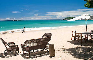
This is one of the best beaches in Sri Lanka. If you are going down South, this might be the best place to have a swim.
The reason to being so famous is that this place is protected by a reef which lies as a wall. So it is safe for your children too. Not only that, but also you have shallow water for diving and for swimming with no risk.
Of course you can hire diving kits, equipments for swimming and also huge tires (which are my favorites :P) for babies.
As I heard SOME of the sellers in there are charging extra money for their instruments from foreigners. Therefore always remember to do those things via your guide… ask him to act as ‘he needs those’

Few years ago, Unawatuna was very rich with its biodiversity. But with the development, we are losing them little by lil. Woods with the various species of plants and animals were flatted to build up hotels. (We need hotels, but they should be situated without harming the nature, savvy?) 
It is not an exaggeration, Unawatuna once selected as one of the twelve best beaches in the world. But with the distraction of Tsunami, the beach loses its sweet peaks. but still providing a fabulous chance to have an unforgettable time with the sea.


If you are seeking the history and the mythical roots relevant to this beach, click here.


Location     : South of Galle, Southern Province.
                     About 120 km from Colombo (from the Airport as well)

                    Turn to Galle-Mathara road (as known as “Mahawela Road”) and drive 4 km         
                    and ask some fellow where is Unawatuna. (Well, asking or talking with a Sri Lankan 
                    is not a criminal!!! I have seen some foreigners who are very shy to talk with
                    Sri Lankans. I’m sure that the guy will show you the path with having a little smile :D  
                    and even sometimes invite you for the lunch!)

Known for   : Swimming, diving, snorkeling, etc

Size/Area   : mmm can’t say exactly, but its enough even for a plane full of tourists!!


Climate      :  mostly Sunny, but can be varied with the changes in weather.


Photo Gallery


Challenge from me:Just let me know how much time you can just staring in the beach looking
                                 at the waves without jumping into it, while your members are having fun in
                                 the water! :P 


Wednesday, November 2, 2011

Royal Botanical Garden, Peradeniya


Royal Botanical Garden, Peradeniya.


This is a famous place among the tourists. Even the Sri Lankans never forget to have a walk there when they are visiting somewhere in the Hill Cities.
I’m describing this at the start because; personally this is the best Garden in Sri Lanka for me. So I thought it would be nicer if I present you my favorites first!


Now I’ll let you a brief Introduction about the garden


Location         : Close to Kandy, in the Central Province


Known for     :  Unique flora

                         Collection of beautiful flowers like Orchids


                           Hundreds of medical plants
                           (you won’t feel nervous, because their names are labeled on themselves)


                          Beautiful sights of palm trees, almost like a fence made by palm trees


                           Large open area with feet-touching grass


                           The Herbarium just next to the garden


Size/Area       : about  147 acres 
                            ( you can understand that you should have a whole day to explore the whole garden)


Climate and    : 460 meters above sea level
Situation            200-day annual rainfall
                         (You should ask guide to find whether the conditions are good) 


Picture Gallery


Challenge from me: Try to find out: - 
                                   there is a classical Avenue of Palms  located in this Garden. 
One tree with a significant history is the Cannonball Would you believe? The tree was planted by King George V of the United Kingdom and Queen Mary in 1901. The tree is bent with its fruits, which look like cannonballs.
                                   Don’t ask your guide about this! He will show you it with in few seconds! So try yourself taking your own time :D
And let me know If you find it


Welcome to Sri Lanka!


The Fist View of Sri Lanka! From the side window of the plane

Welcome to Sri Lanka, the pearl of the Indian Ocean, the miracle of Asia!
Never mind from where you are, you’ll let your first step in Sri Lanka at Bandaranaike International Airport, Katunayaka.
So from there, with the help of a guide you can enjoy the vast glamorous of Sri Lanka.
In that time, with the help of these information in this blog, you can ask the guide to go somewhere instead of accepting his plans! (Don’t refuse all their points, because they are born to guide! lol  :D)


Now, let me show where are you right now from a map

<Map: Katunayake>

(hint: by zooming out, you can get the exact idea about the location)

 
Katunayake is situated in the Gampaha District, Western Province.
When you get out from the airport and turn to the main street, some of you may feel “oh, is this the beauty of Sri Lanka? We do have these kinds of huge buildings, roads full of Traffic in our own country. This is not what we expected”  ,yeah something like that.
But, WAIT! BE PATIENT! 
The drama is not yet started!! :D

You are running in the Western Province which is the most urbanized state of Sri Lanka, and where the basement of the development of technology and other stuff. As a result of industrialization, we lost the environmental-friendly surrounding in that state for a great extent L

From here I've to divide the plans… 
Because from Colombo, you will have to decide where are you going first.
If you are wishing to go on a coastal street with the sun and later having an enjoyable swim, you may choose to go down South.
If you are wishing to experience the nature with coooool temperature (more “o” s to imply how cool it is :P)  and later come up with a  bonfire, you may visit Hill City, that means the Central Province
If you are wishing to explore the ancient buildings, statues, temples, huge tanks and such ruins, you may ask to go up to North-Central Province

Well, well, I can’t just describe every condition here (I’m little bit drowsy in typing at the moment :P  hehe!) 
With the next posts I’ll describe some fabulous places in here, and please notice what are you interested and then at the first meeting of your guide, you just tell him all those places and he will arrange a circle (a chain) of them as a fantastic journey.

-Pasindu  

Introduction


I wish this blog would be very helpful to any Tourist who is about to visit Sri Lanka and also anyone seeking information about Sri Lanka.But I'm not guarantying any of the following information, because as the change of Climate, etc, these things may be subjected to change. But as a Sri Lankan, I recommend these places to be added to your visiting plan in Sri Lanka, if you wish to get an exquisite experience. :)


And also if you need more help, just let me know and I’ll try my best on that :)
You may leave your question here in the blog and I'll reply all of them as soon as possible.

Finally, if you think this blog is useful, please leave me a comment and then I may get more action to upgrade it with more info :D

Thanks!
-Pasindu


ps : taking about me: I’m a 20 years old boy. Did the A/L exam in August and expecting results :)